Contact Info

Office Coastal Zone Management Complex, Princess Margaret Drive, Belize City

Call +501-203-26235

Email hello@fisheries.gov.bz

Weather

Belize City
WeatherClear(clear sky)

27

°C
Weather10.4mph
Weather0%
Weather76%
27°Weather
Weather26°
27
°C
Weather
Thu
27
°C
Weather
Fri
27
°C
Weather
Sat
27
°C
Weather
Sun
28
°C
Weather
Mon

PHMR

Port Honduras Marine Reserve
1
Year Established
1
Acres

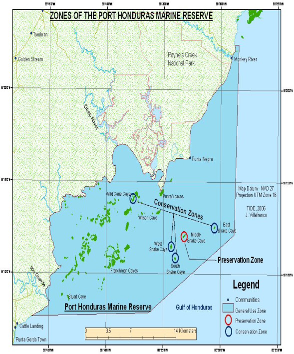
Port Honduras Marine Reserve (PHMR), in the southern coastal waters of Belize, is a semi-estuarine system that stretches from Monkey River to beyond Rio Grande, extending approximately 8 kilometers out to sea.

PHMR was first established in 2000 for its role in maintaining the viability of local populations of the West Indian manatee. Following its establishment, the reserve has also been highlighted for its value as a fish nursery area and was included in national requirements for biodiversity protection.

 It contains a diverse set of ecosystems – coastal and tidal wetlands, coral reef, extensive sea-grass and mangrove, but excludes the approximately 240 cayes lying within the overall area. An important resource for local fishermen, the marine reserve has also been highlighted for its relatively high value as a fish nursery area, and its role in maintaining the viability of local manatee populations.

+501-722-2274

Contact the PHMR's Management Team
Fisheries Department, in partnership with the Environmental Defense Fund (EDF), the Toledo Institute for Development and Environment (TIDE) and the Wildlife Conservation Society (WCS), under the Sustainable Fisheries Initiative (SFI) in Belize, has been implementing Managed Access as a pilot program in Port Honduras Marine Reserve (PHMR) and Glover’s Reef Marine Reserve as a first step towards the implementation of Catch Shares as a national fisheries management policy for Belize. The ultimate goal of the program is to improve the sustainability of fishing in Belize.

The ranger station, located strategically on Abalone Caye in the middle of the reserve, is the central hub for TIDE’s enforcement and research activities. Its central location allow for more patrol effectiveness (particularly in the Snake Caye Replenishment Zones), requiring less effort from fisheries to submit Managed Access catch data on the caye, allowing for increased effectiveness of the pilot program. A team of TIDE rangers based at the newly refurbished ranger station at Abalone Caye carries out enforcement throughout the reserve.

Rules and Regulations

All Zones

The use of long-lines, gill nets and beach traps is prohibited throughout the reserve.

General Use Zone (95%)

Commercial, subsistence and recreational fishing are permitted, within the limits of Managed Access.

Replenishment Zone (4%)

Only non-extractive recreational activities are permitted.

Preservation Zone (1%)

No person is permitted entry unless for pre-approved, non-extractive research purposes.

Report an Incident


    If available, upload document or photo.