BCMR
Bacalar CHico Marine Reserve
The Bacalar Chico National Park and Marine Reserve (BCNPMR) was designated under the National Parks System Act in 1996. Following a decade of advocacy, in that same year, the Belize Barrier Reef System was inscribed as a United Nations Educational, Scientific and Cultural Organization (UNESCO) World Heritage Site: one of less than 1,000 worldwide. BCNPMR was included as one of the seven sites within this designation which recognized the Belize Barrier Reef System as the largest barrier reef in the Northern hemisphere, representing fringing, barrier and atoll reef types.
As a mixed terrestrial and marine reserve the 28,169 acre area is co-managed by the Fisheries Department and Forestry Department under Belize’s Ministry of Agriculture, Fisheries, Forestry, The Environment and Sustainable Development. The management objectives are:
- To ensure the health of the fishery stock
- To regulate water sports
- To conduct monitoring and assist in research
- To provide job opportunities to tour guides and a venue for recreational activities
- To prohibit illegal fishing and deter other illegal activities which may be detrimental to the health of the flora and fauna.
In 2003 under the Meso-American Barrier Reef Systems project a multipurpose center was built at San Juan housing an informative visitor center, equipment storage and ranger accommodations in an effort to improve protected area management and strengthen public education and awareness programs about the unique area.
In 2014 the low impact Ecological and Educational Center facilities were completed to accommodate researchers, students, educational groups and overnight visitors wishing to engage in activities compatible with the resource management/protection goals of the reserves.
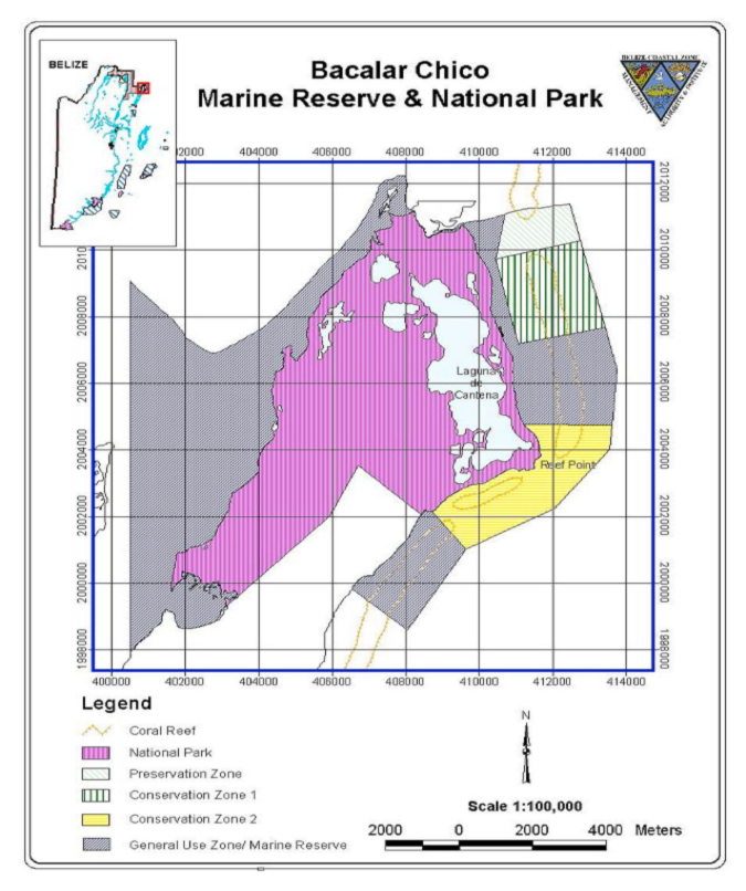
BCNPMR occupies the northern end of Ambergris Caye, reaching from Chetumal Bay in the west to the Caribbean Sea in the east, and encompasses over 28,000 acres. It has a 12, 640 acre terrestrial portion, which includes the Bacalar Lagoon, also called the Laguna de Cantena. The adjacent 15,529 acre marine reserve portion is part of the Belize Barrier Reef.
The location and boundaries of Bacalar Chico National Park and Marine Reserve is comprised of five management zones (National Park and four Marine Reserve Zones) of the protected area.
Rules and Regulations
General Use Zone 1 & 2
- There is restricted fishing. Fishermen must have a fishing license and the boat must be registered with the Fisheries Department
- Only Bacalar Chico residents are allowed to fish for subsistence purposes which does not include lobster and conch species
- There is not be use of long lines, spear guns or gill nets
- No traps made with seine, cast nets, gill nets, trammel nets or tangle nets are permitted
- Nets can only be used to round up fish within a beach trap
- Each trap must be monitored daily. Birds, Manatees, rays, turtles, crocodiles, nurse sharks and dolphin caught in the traps must be released
- No beach trap can trap fish beyond its capacity. Fish must be removed every three days and juveniles released. If beach trap owners do not maintain their traps, within two years they will lose their beach traps
- No person shall, within the General Use Zone, cast or drag any anchor in any manner which may damage coral
Preservation Zone
- No fishing, sport fishing, diving, or any other water activity is permitted
- No motorised boats are permitted except with written permission from the Fisheries Administrator
Conservation Zones
- No boat is to be secured to the sea bed except in designated mooring areas, unless they have written permission from the Reserve Manager or in the case of an emergency
- Divers must register with the Reserve before entering
- Charter dives must possess a license, and all dive boats must fly the ‘divers below flag'
- Only certified SCUBA divers or divers undergoing a training course are allowed to dive
- Dive guides must explain the rules of the reserve to their divers
Conservation Zone 1
- Only non-extractive recreational activities can take place
Conservation Zone 2
- Spear fishing is not permitted
- Only trolling is allowed during the months of December to February in each year
- During Catch and release fishing tours fish can only be removed for subsistence only
Research
The Bacalar Chico Rangers carry out a range of inventory, monitoring, research and resource management initiatives in coordination with research partners- Bird surveys collecting data on species type and abundance at sites to include Laguna de Cantena, the Bacalar Chico Canal and the San Juan Field Station areas
- Lobster and conch, including Queen Conch. Abundance and distribution is measured by monitoring sites in each of the five marine reserve management zones
- Sites randomly selected as representative habitats of the surrounding area are monitored under the Synoptic Monitoring Program (SMP): a regional program developed to collect information on the health of the Barrier Reef and its associated ecosystems, in order to assist in the management and conservation of the reef. Data is collected on coral and algae cover, parrotfish (a keystone species), commercial fish species, juvenile fish species, Diadema (sea urchins)
- Spawning Aggregation Surveys (SAS) are conducted off Rocky Point to gather data on important species including Black Grouper, Margate, and Cuba Snapper
- Sea grass surveys are conducted in several locations to monitor sea grass condition and health
- During the turtle nesting period, the nesting beach is monitored at least two times per week in order to record any new nest and conduct conservation activities
- Monitoring of sport and commercial fishing catches
